Bangkok Flooding: Aerial Views of the Flood (part one)

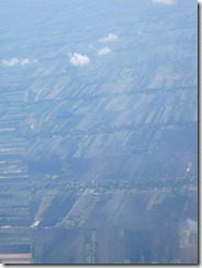
Here is the first of two sets of photos of the flood approaching Bangkok. The flooding stretches for miles! We flew over flooded areas for at least 15 minutes. You can see farmlands, roads, and buildings underwater. It’s going to take awhile for the land to dry out, perhaps 4-6 weeks as suggested by the authorities.

2011_10_22 Aerial Photos (2)2011_10_22 Aerial Photos (3)2011_10_22 Aerial Photos (4)2011_10_22 Aerial Photos (5)2011_10_22 Aerial Photos (6)2011_10_22 Aerial Photos (7)2011_10_22 Aerial Photos (10)2011_10_22 Aerial Photos (11)2011_10_22 Aerial Photos (12)2011_10_22 Aerial Photos (13)2011_10_22 Aerial Photos (14)2011_10_22 Aerial Photos (15)2011_10_22 Aerial Photos (16)2011_10_22 Aerial Photos (17)

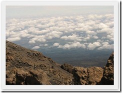
Here are few photos of what the landscape would look like if it were dry.

2011_10_22 Aerial Photos

2011_10_22 Aerial Photos (9)

2011_10_22 Aerial Photos (8)

Write a Comment

Your email address will not be published. Required fields are marked *