
The good news on the flooding situation in northern Bangkok is that as of this afternoon, October 22, the floodwaters have been isolated to some streets on the eastern side of the river in the more urban areas of Nonthaburi Province. The same cannot be said of the western side, where Bang Bua Thong district in Nonthaburi on the outskirts of Bangkok sustained severe flooding. The situation seems to be worsening, albeit not as quickly as expected.
Today, we flew over the flooded areas north of Bangkok on our way to Chiang Rai, where we are now waiting out the floods. The bad news is that the area covered in water is absolutely huge! We flew at least 15 minutes over areas submerged in water; farmland, highways, and towns alike. Most of the water has no place to go except south toward Bangkok. Based on my own observations, I think the city is in for a sustained deluge rather than a quick dousing. Who knows how long this will last.
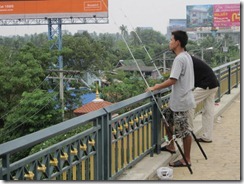
These photos were taken around noon on October 20 at the Rama IV Bridge in Nonthaburi. The river is bloated, and water levels are high. I imagine they’re even higher today, although I cannot confirm it.
")
")
")
")
")
")
")
")
")
Koh Kred Island is even more flooded than when we visited in September.
")
")
Boats are a more effective means of transportation than automobiles in some parts of the city.
")
")
")
")
And the fishing just keeps getting better and better.


[…] 12. Bangkok Flooding: Views from Rama IV Bridge […]