
Bangkok Flooding: Aerial Views of the Flood (part three)
We returned to Bangkok yesterday. Fortunately, our trip home was uneventful. The expressways are open, and the authorities are starting to tow vehicles parked illegally and fine the owners 500 Thai baht (about $16.50), so traffic moved at a reasonable pace. We didn’t see a lot of standing water in central Bangkok on our way home.
Suvarnabhumi International Airport was open and as busy as ever. It could get even busier with the city’s other major airport, Don Mueang, closed for at least a week after water inundated the runway. The flooding situation in Nonthaburi Province north of Bangkok has stabilized, but reports have started to roll in of isolated flooding in some parts of Bangkok. Eyewitnesses reported seeing flooding on Khao San Road, one of the main arterials downtown near the Chao Phraya River. The Bangkok Post posted photos of flooding near the Grand Palace, one of the city’s main attractions. The general assumption is that the closer you are to the river, the more likely you are to see flooding.
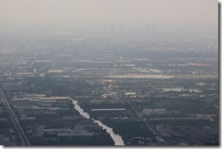
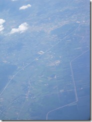
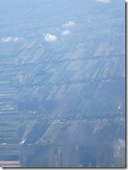
Below are aerial photos taken October 25 during our return flight to Bangkok. The flooding situation has not changed much in the provinces north of the city. It’s going to take weeks for things to dry out.
")
")
")
")
")
")
")
")
")
")
")
")
")
")
")
")
")

")
")
")
")
")
")
")
")
")
")
")
")
")
")
")
")
")
")
")
")
")
")
")
")
")
")
")
")
")
")
")
")
")
")

")
")