The Fight to Stop Bangkok from Flooding

October 18, 2011

8 a.m. Local Time

Bangkok, Thailand

The Bangkok Post reported that the floodwaters from the Chao Phraya River have reached Sai Mai district less than 20 kilometers from here. Local authorities have advised that although the situation has worsened in the last 48 hours, we are still safe from flooding because we are in a protected area. A large number of government buildings are in the area, and keeping the floods at bay is a priority.

2011_10_14 Bangkok Flooding (40)

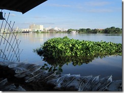
According to the Post, Sai Mai, which is a couple kilometers from Don Mueang (domestic) Airport, is a strategic battleground. Failure to hold the line puts even more of Bangkok at risk. The flooding has so far moved in waves and covered entire sections of the country with amazing speed. Local residents and work crews are working hard to shore up barriers with dirt and sandbags in order to funnel the floodwaters to the sea, but it’s not clear that their heroic efforts will be enough.

2011_10_14 Bangkok Flooding (16)

This seems to be turning into a battle of all or nothing.  Either the defenses hold and the crisis subsides, or soon we will all be underwater.

2011_10_14 Bangkok Flooding (11)

Update 7:30 p.m. Local Time

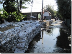
The neighborhood has taken precautions to halt the water if it reaches here. Some streets have been shut down and barricaded with sandbag barriers. Dirt berms have been built over some roads to stop the water from going further. School has been canceled through the end of next week’s school break. We’ve been informed of a hotel where we can find shelter if need be. The water feels closer.

2011_10_14 Bangkok Flooding (24)

Tomorrow some of us will go out as far as we can safely to survey the situation. I’ll report back on whatever I find.

2011_10_14 Bangkok Flooding (20)

Bangkok Flooding Update with Photos

October 17, 2011

6:00 p.m. Local Time

Bangkok, Thailand

This weekend I drove around areas of Bangkok flooded by the Chao Phraya River. The water had crested its banks by 1.5 meters and flooded temples, businesses, and homes located along the river. We saw work crews busy building makeshift levees with sandbags and dirt mounds at points along the road deemed most likely to withstand the flood.

As long as the river does not rise another two meters, I think the urban areas of Bangkok will be spared from large-scale flooding. The area that I toured in Nonthaburi Province is considered at higher risk than Bangkok.

Based on my own observations, I think that we are safe for now. However, if the river rises 3-5 meters more, we’ll all be in trouble. From the looks of it though, I think the floodwaters here will be minimal.

Update, 8:30 p.m. Local Time

According to a news article in the Bangkok Post, a water barrier in Pathum Thani’s Khlong Luang district about 30 kilometers to the north of Nonthaburi ruptured earlier today, flooding the area. Hold on; we’re not through this yet.

October 18, 2011

7:30 p.m. Local Time

Bangkok, Thailand

We’ve been informed that the flooding at Khlong Luang district should not affect us in Nonthaburi. For the time being, we’re safe, although Bangkok is still an island surrounded by flooded land to the north, east, and west. Let’s hope it drains to the Gulf of Thailand without more problems cropping up.

The following are photos I took over the past two days. Photos tell the story much better than I.

2011_10_14 Bangkok Flooding (33)

2011_10_14 Bangkok Flooding

2011_10_14 Bangkok Flooding (4)

2011_10_14 Bangkok Flooding (6)

2011_10_14 Bangkok Flooding (8)

2011_10_14 Bangkok Flooding (10)

2011_10_14 Bangkok Flooding (18)

2011_10_14 Bangkok Flooding (21)

2011_10_14 Bangkok Flooding (25)

2011_10_14 Bangkok Flooding (28)

2011_10_14 Bangkok Flooding (29)

2011_10_14 Bangkok Flooding (30)

2011_10_14 Bangkok Flooding (31)

2011_10_14 Bangkok Flooding (34)

2011_10_14 Bangkok Flooding (36)

2011_10_14 Bangkok Flooding (38)

2011_10_14 Bangkok Flooding (39)

2011_10_14 Bangkok Flooding (41)

2011_10_14 Bangkok Flooding (42)

Bangkok Floods

October 14, 2011

7:00 p.m. Local Time

Bangkok, Thailand

You’ve probably heard about the flooding in Thailand that has left over 280 dead, millions displaced, and over six million hectares underwater.  The estimated cost of the damage could run upwards of $5 billion by the time this is over.  On the ground, the situation seems as serious as the media is portraying it to be, although the mood is generally upbeat.  People are cautiously optimistic that the worst has passed.  That, of course, is cold comfort to the million of people already affected by the flooding and the residents of eastern and western Bangkok who will soon be homeless as the excess water is siphoned through their areas.  Nor does it take into account that the rains haven’t stopped yet.  A thunderstorm with heavy showers just passed through the area.

As of this writing, the Bangkok suburb of Nonthaburi is still “dry.”  The flooding is not as bad here as it is 45 minutes upriver in Ayutthaya.  Water from the Chao Phraya River has overflowed the river’s banks about five kilometers from here and flooded the temple grounds at Wat Bangchak and neighboring Koh Kred Island.  Flooding has not yet reached the city’s main thoroughfares, Chaengwatthana and Tiwanon roads.  If the water breaches those fortified arterials and rises half a meter, then the flooding could spread here.

I’ve heard that water level will continue to rise through Monday, October 17.  Until then, we’ll wait and see.  We’ve hunkered down and made some preparations in the event that our home turns into a swimming pool.  Regardless of the outcome, it will take awhile for life to get back to normal here for all of us.

Tomorrow I plan to drive around to survey the extent of the damage in the area and take photos.  I will post them if I see flooding.