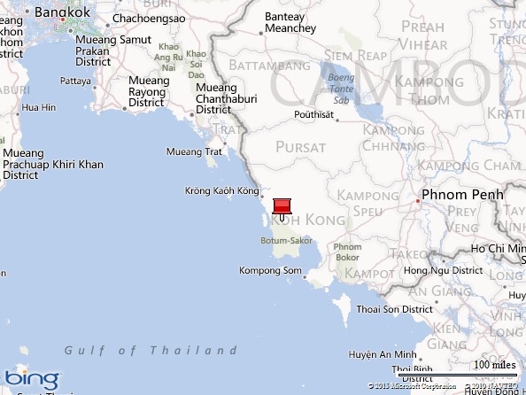
The Cambodian Coast–Koh Kong

This is the final article in a four-part series about the Cambodian Coast. This one is about Koh Kong, a coastal city in western Cambodia on the Cambodian-Thai border. Previous articles featured National Highway 4 heading from Phnom Penh to the coast, National Highway 48 along the coast, and the coastal wilderness. This series is intended as a resource for those interested in exploring this intriguing area of Cambodia.

After a long day driving from Phnom Penh through the Cambodian wilderness on New Year’s Eve 2012, we arrived in Koh Kong City at nightfall.

nh48

I wished that we could have stayed in town but had to settle for a rural lodge several kilometers up the road. We stopped for a quick sunset photo on the Koh Kong City waterfront and headed to our hotel. I suddenly fell ill and celebrated the New Year in bed with a fever. What I thought were symptoms of dengue fever turned into a 24-hour flu, and thankfully I felt better in the morning.

2013_01_01 Cambodia Koh Kong

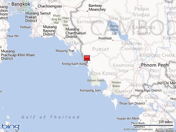
The next day we drove the 7-kilometer long Koh Kong Bridge back to town. Built in 2002, the bridge spans the mouth of the wide but shallow Prek Kaoh (Kah Bpow) River.

2013_01_01 Cambodia Koh Kong (15)

2013_01_01 Cambodia Koh Kong (17)

2013_01_01 Cambodia Koh Kong (18)

The capital of Koh Kong Province and largest city in Cambodia’s western coastal region, Koh Kong City has a population of more than 35,000 but looks smaller with its residents scattered across a large area. With no stoplights and little traffic, the city streets resembled a ghost town when we visited. The city has long had a reputation as a “Wild West” frontier town and a haven for smugglers, but recent efforts to improve access via Highway 48 has helped integrate it with the rest of the country. It’s now more of a convenient stopover on the way from Phnom Penh to Bangkok, Thailand than a remote outpost.

2013_01_01 Cambodia Koh Kong (1)

2013_01_01 Cambodia Koh Kong (2)

2013_01_01 Cambodia Koh Kong (3)

The regional branch of the National Bank of Cambodia, also known as the “Red House,” is one of the more recognizable landmarks in town. It’s more pink than red, but who’s quibbling?

2013_01_01 Cambodia Koh Kong (8)

This lodge in the town center had a uniquely Kampuchean (former Khmer Rouge Cambodia) look to it with an odd melding of Cambodia architecture and communist symbolism.

2013_01_01 Cambodia Koh Kong (23)

Canals and boat moorings crisscrossed the city center, creating picturesque views and great photo opportunities.

2013_01_01 Cambodia Koh Kong (4)

2013_01_01 Cambodia Koh Kong (5)

2013_01_01 Cambodia Koh Kong (6)

2013_01_01 Cambodia Koh Kong (7)

When we visited, the city was in the process of sprucing up the waterfront, paving roads, and laying sidewalks in what looked like a half-hearted attempt to attract tourists, but it seemed like local officials were in no hurry to finish any projects. The place had an unkempt charm and organic look that centralized planning couldn’t duplicate. The tropical scenery just past the city center that gave the town a wild vibe.

2013_01_01 Cambodia Koh Kong (11)

2013_01_01 Cambodia Koh Kong (12)

2013_01_01 Cambodia Koh Kong (9)

2013_01_01 Cambodia Koh Kong (10)

Koh Kong City has both Buddhist and Muslim communities served by the Neang Kok Temple and Al-Mubarak Dubai Mosque. We saw Buddhist statues in a local park and two monks asking a local store for alms.

2013_01_01 Cambodia Koh Kong (13)

2013_01_01 Cambodia Koh Kong (14)

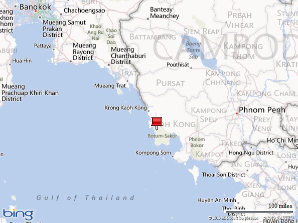
After our brief tour of Koh Kong City, we crossed the Koh Kong Bridge again and drove to the Cambodian-Thai border. The Prek Kaoh River looked more like a lake than a river.

2013_01_01 Cambodia Koh Kong (16)

2013_01_01 Cambodia Koh Kong (19)

2013_01_01 Cambodia Koh Kong (20)

On the way to the Cambodia-Thailand border, we passed a hodgepodge of eclectic architecture, including a Thai-style Buddhist shrine, Khmer-style gate, and the gaudy entrance to the Koh Kong Safari World Resort.

2013_01_01 Cambodia Koh Kong (21)

2013_01_01 Cambodia Koh Kong (22)

2013_01_01 Cambodia Koh Kong (25)

2013_01_01 Cambodia Koh Kong (26)

2013_01_01 Cambodia Koh Kong (24)

The drive from Koh Kong City to the border is about ten kilometers through some pretty countryside punctuated by a few beach resorts and homes. It’s one of the more organized, orderly, and uncrowded border crossings I’ve seen.

2013_01_01 Cambodia Koh Kong (27)

2013_01_01 Cambodia Koh Kong (28)

2013_01_01 Cambodia Koh Kong (29)

2013_01_01 Cambodia Koh Kong (30)

2013_01_01 Cambodia Koh Kong (31)

Although crossing into Thailand was somewhat confusing with few English speakers in the Customs and Immigration offices on both sides of the border, we made it through and entered Thailand after sorting out paperwork and communicating in hand signals.

For more information about driving in Cambodia, contact me at me@mgedwards.com.

More About the Cambodian Coast

Heading to the Coast (National Highway 4)

Driving the Coast (National Highway 48)

The Cambodian Wilderness

Map picture


clip_image002[4]

M.G. Edwards is a writer of books and stories in the mystery, thriller and science fiction-fantasy genres. He also writes travel adventures. He is author of Kilimanjaro: One Man’s Quest to Go Over the Hill, a non-fiction account of his attempt to summit Mount Kilimanjaro, Africa’s highest mountain, and a short story collection called Real Dreams: Thirty Years of Short Stories. He also wrote and illustrated Alexander the Salamander and Ellie the Elephant, two books in the World Adventurers for Kids Series. His books are available in e-book and print from Amazon.com and other booksellers. Edwards graduated from the University of Washington with a master’s degree in China Studies and a Master of Business Administration. He lives in Bangkok, Thailand with his wife Jing and son Alex.

For more books or stories by M.G. Edwards, visit his web site at www.mgedwards.com or his blog, World Adventurers. Contact him at me@mgedwards.com, on Facebook, on Google+, or @m_g_edwards on Twitter.

© 2013 Brilliance Press. All rights reserved. No part of this work may be reproduced or transmitted without the written consent of the author.

The Cambodian Coast-Coastal Wilderness

This is the third article in a four-part series about the Cambodian Coast. This blog post is about the Cambodian coastal wilderness, Botum Sakor National Park, and Peam Krasaop Wildlife Corridor. The first two articles featured National Highway 4 southwest of Cambodia’s capital, Phnom Penh, and National Highway 48 along the western coast. The final post will focus on the Koh Kong, a coastal city in western Cambodia and the Cambodian-Thai border. This series is intended to be a resource for those interested in touring the Cambodian coast.

When my family and I visited Cambodia in December 2012, we drove from Phnom Penh to the city of Koh Kong on the Cambodia-Thailand border. Along the way we passed through the country’s pristine southwestern wilderness. To the south, Botum Sakor National Park lay on a peninsula between the Gulf of Thailand and Kampong Som Bay. To the west, the Peam Krasaop Wildlife Corridor hugged the coast near the city of Koh Kong. To the northeast, the rolling Cardamom Mountains stretched from Thailand to the coast. It’s a spectacular triangle filled with scenic beauty in one of the most isolated corners of Southeast Asia.

nh48

Home to the second-largest wilderness in Southeast Asia (the largest is in Burma/Myanmar), the Cambodian coast has one of the largest native forests still left in Southeast Asia. It’s a place rich in beauty and diversity explored by few. Wildlife inhabits the forests and wetlands along the coast. Although there have been reports of illegal logging, poaching, and development in the area that may have had an affect on the local ecology and threatened local wildlife, it was unclear how widespread the damage was when I passed through. Improvements to National Highway 48 have made the region more accessible to people but also increased the human footprint here.

We saw some incredibly beautiful scenery during our drive through the Cambodian wilderness. Here are some of the best landscape shots.

2012_12_31 Cambodia Wilderness (2)

2012_12_31 Cambodia Wilderness (3)

2012_12_31 Cambodia Wilderness (5)

2012_12_31 Cambodia Wilderness (7)

2012_12_31 Cambodia Wilderness (9)

2012_12_31 Cambodia Wilderness (10)

2012_12_31 Cambodia Wilderness (12)

2012_12_31 Cambodia Wilderness (13)

2012_12_31 Cambodia Wilderness (16)

2012_12_31 Cambodia Wilderness (17)

2012_12_31 Cambodia Wilderness (18)

2012_12_31 Cambodia Wilderness (19)

2012_12_31 Cambodia Wilderness (21)

2012_12_31 Cambodia Wilderness (23)

As far as we could tell from our limited vantage point, humans seemed to coexist harmoniously with nature. While there was some clutter such as a broken-down vehicle and road-side litter along, the local residents seemed to take care of their environment. The forests we saw were generally intact.

2012_12_31 Cambodia Wilderness (8)

2012_12_31 Cambodia Wilderness (1)

2012_12_31 Cambodia Wilderness (11)

2012_12_31 Cambodia Wilderness (24)

2012_12_31 Cambodia Wilderness (20)

2012_12_31 Cambodia Wilderness (15)

2012_12_31 Cambodia Wilderness (14)

2012_12_31 Cambodia Wilderness (6)

2012_12_31 Cambodia Wilderness (22)

2012_12_31 Cambodia Wilderness (4)

At the end of our wandering in the Cambodian wilderness, we were treated to a gorgeous sunset.

2012_12_31 Cambodia Wilderness (26)

2012_12_31 Cambodia Wilderness (27)

2012_12_31 Cambodia Wilderness (28)

2012_12_31 Cambodia Wilderness (29)

2012_12_31 Cambodia Wilderness (30)

2012_12_31 Cambodia Wilderness (31)

2012_12_31 Cambodia Wilderness (32)

2012_12_31 Cambodia Wilderness

For more information about driving in Cambodia, contact me at me@mgedwards.com.

More About the Cambodian Coast

Heading to the Coast (National Highway 4)

Driving the Coast (National Highway 48)

Koh Kong City and the Cambodia-Thailand Border

Map picture

clip_image002M.G. Edwards is a writer of books and stories in the mystery, thriller and science fiction-fantasy genres. He also writes travel adventures. He is author of Kilimanjaro: One Man’s Quest to Go Over the Hill, a non-fiction account of his attempt to summit Mount Kilimanjaro, Africa’s highest mountain, and a short story collection called Real Dreams: Thirty Years of Short Stories. He also wrote and illustrated Alexander the Salamander and Ellie the Elephant, two books in the World Adventurers for Kids Series. His books are available in e-book and print from Amazon.com and other booksellers. Edwards graduated from the University of Washington with a master’s degree in China Studies and a Master of Business Administration. He lives in Bangkok, Thailand with his wife Jing and son Alex.

For more books or stories by M.G. Edwards, visit his web site at www.mgedwards.com or his blog, World Adventurers. Contact him at me@mgedwards.com, on Facebook, on Google+, or @m_g_edwards on Twitter.

© 2013 Brilliance Press. All rights reserved. No part of this work may be reproduced or transmitted without the written consent of the author.

The Cambodian Coast–Driving the Coast

This is the second article in a four-part series about the Cambodian Coast. This post is about the drive along coastal Highway 48. The first article featured the drive on National Highway 4 from Cambodia’s capital, Phnom Penh, toward Sihanoukville. Future posts will focus on the Cambodian wilderness and Koh Kong, a coastal city in western Cambodia near the border of Thailand. This series is intended to be a resource for those interested in driving the Cambodian coast.

During my family’s drive through Cambodia in December 2012, we headed from the capital Phnom Penh to the coast via National Highway 4 (NH4). After a nerve-wracking drive filled with an assortment of traffic – trucks, cars, motos, buses, bicycles, tractors, pedestrians, cows, chickens, carts, and anything else that moved – potholes, speed bumps, toll booths, and bad drivers, I was more than glad to turn off onto the secondary National Highway 48 (NH48). It wasn’t just quiet – it was too quiet. We passed a few trucks, cars, and bicycles but not much else. It was as if this road newly accessible to the world had yet to be discovered as an alternate route from Phnom Penh to Thailand.

nh48

One of the least populated areas of Southeast Asia, the coastal region of Cambodia wedged between the Gulf of Thailand and the Cardamom Mountains is a true wilderness with virgin forests, rolling hills, and wildlife that mingles with the few locals, mostly farmers and fishermen, who live along the coast. If you have time during your Cambodia trip after requisite stops in Siem Reap (Angkor) and Phnom Penh, consider adding the coast to your itinerary. Botum Sakor National Park, Peam Krasaop Wildlife Corridor, and the surrounding region offer a view of Southeast Asia you rarely see.

This coast is an as-yet unspoiled gem protected by years of remote isolation. The only highway in the area, NH48, was built in 2003. The notoriously slow ferry crossings across wide rivers that hindered travel in the region were replaced by five concrete bridges in 2011. The bridges made the coast much more accessible, and tourists can now easily tour the area by car or bus.

The drive from NH4 to Koh Kong, a city on Cambodia’s southwestern border with Thailand, takes about 4.5 hours in good driving conditions. If you’re planning a trip to Cambodia’s coast, the photos in this travelogue will give you an idea of what to expect. These photos were taken in December 2012. Note that road conditions are subject to change.

For the first half hour of the drive, NH48 is tarred and sealed with rock chip and in good condition from the junction of National Highway 4 to the Srae Ambel River crossing. Traffic was light with some trucks hauling heavy freight and cows wandering on the side of the road. The concrete bridge was solid. The countryside in this area offered beautiful views of low-lying mountains to the northeast. A Buddhist temple and monastery just off the highway reminded me that I was in Southeast Asia.

2012_12_31 Cambodia Coast (1)

2012_12_31 Cambodia Coast (2)

2012_12_31 Cambodia Coast (3)

2012_12_31 Cambodia Coast (4)

2012_12_31 Cambodia Coast (5)

For the next hour beyond the Srae Ambel River, the road showed signs of aging and the affects of the rainy season with warping, pavement chafing, and potholes – nothing unavoidable if you drive at a prudent speed. The landscape was flat with some picturesque scenery that included some quaint bungalows, rice fields and fish ponds interspersed with wild foliage.

2012_12_31 Cambodia Coast (6)

2012_12_31 Cambodia Coast (7)

2012_12_31 Cambodia Coast (8)

2012_12_31 Cambodia Coast (9)

2012_12_31 Cambodia Coast (10)

The road quality was fair as I drove west on NH48 toward Koh Kong and passed the second new concrete bridge crossing a river that flowed into Kampong Som Bay on the Gulf of Thailand.

2012_12_31 Cambodia Coast (11)

About 1.5 hours into our journey, we arrived at the town of Andong Terk and crossed the wide Preak Piphot River not far from the mouth of the Kampong Som Bay. This large, brand-new bridge spanned the river in a high arch that allowed fishing boats to pass below. We stopped on the bridge and took some great photos of the gorgeous river and delta that spread out below in all directions.

2012_12_31 Cambodia Coast (12)

2012_12_31 Cambodia Coast (13)

2012_12_31 Cambodia Coast (14)

2012_12_31 Cambodia Coast (15)

We drove on through the foothills of the Cardamom Mountains along the northern edge of Botum Sakor National Park. While we didn’t spot much wildlife, we did see some beautiful views. At this point our GPS loaded with Cambodia maps failed and could not pinpoint our location. We knew then that we had really gone off the beaten path! Considering that there was just one paved highway in the area, we were confident that the road would bring us to our destination, Koh Kong. Eventually.

2012_12_31 Cambodia Coast (16)

2012_12_31 Cambodia Coast (17)

2012_12_31 Cambodia Coast (18)

2012_12_31 Cambodia Coast (19)

The road was in poor condition through the national park with severe warping and some axle-bending potholes. Our vehicle had to creep through some place where the highway had become a washboard. To make matters worse, the road grew winding and traffic volumes increased as trucks slowed down to navigate their way around the tricky potholes and curves.

2012_12_31 Cambodia Coast (20)

2012_12_31 Cambodia Coast (21)

2012_12_31 Cambodia Coast (22)

The road condition improved after we passed the fourth bridge across the Khlang Yai River at the small town of Trapeang Rung. The Cardamom Mountains offered stunning views in this area. Although the road surface was better here, the highway wound through the mountains in sharp curves. With dusk approaching and another 1.5 hours to drive, I had to consider both the road condition and the fact that driving in the dark on an unknown route was difficult. It turned into a race between sundown and reaching Koh Kong.

2012_12_31 Cambodia Coast (23)

2012_12_31 Cambodia Coast (24)

2012_12_31 Cambodia Coast (25)

2012_12_31 Cambodia Coast (26)

2012_12_31 Cambodia Coast (27)

2012_12_31 Cambodia Coast (28)

2012_12_31 Cambodia Coast (29)

2012_12_31 Cambodia Coast (30)

An hour later, we arrived at the Tatai River, our final crossing before Koh Kong. This was the most picturesque location on our drive. Pointing at the stilt homes with rusty corrugated roofs along the river’s edge and the tropical forest beyond, I told my wife, “We’re definitely in Southeast Asia! Look at this view.” The colorful houses and boats persuaded me that despite the frustrations along the way – the traffic, roads, driving into the unknown – the trip was worth the effort.

2012_12_31 Cambodia Coast (31)

2012_12_31 Cambodia Coast (32)

2012_12_31 Cambodia Coast (33)

2012_12_31 Cambodia Coast (34)

2012_12_31 Cambodia Coast (35)

2012_12_31 Cambodia Coast (36)

We drove the final half hour to Koh Kong on battered roads. As the sun set, the light faded to gray, and the dim light cast a rose-colored hue before the shadows and darkness set in. I wanted to enjoy the view but had to focus on reaching Koh Kong before nightfall. The twinkle of city lights in the valley beyond the Cardamom Mountains assured me that we would arrive before nightfall. And we did.

2012_12_31 Cambodia Coast (37)

2012_12_31 Cambodia Coast (38)

2012_12_31 Cambodia Coast (39)

2012_12_31 Cambodia Coast

For more information about driving in Cambodia, contact me at me@mgedwards.com.

More About the Cambodian Coast

Heading to the Coast (National Highway 4)

The Cambodian Wilderness

Koh Kong City and the Cambodia-Thailand Border

Map picture


M.G. Edclip_image002wards is a writer of books and stories in the mystery, thriller and science fiction-fantasy genres. He also writes travel adventures. He is author of Kilimanjaro: One Man’s Quest to Go Over the Hill, a non-fiction account of his attempt to summit Mount Kilimanjaro, Africa’s highest mountain, and a short story collection called Real Dreams: Thirty Years of Short Stories. He also wrote and illustrated Alexander the Salamander and Ellie the Elephant, two books in the World Adventurers for Kids Series. His books are available in e-book and print from Amazon.com and other booksellers. Edwards graduated from the University of Washington with a master’s degree in China Studies and a Master of Business Administration. He lives in Bangkok, Thailand with his wife Jing and son Alex.

For more books or stories by M.G. Edwards, visit his web site at www.mgedwards.com or his blog, World Adventurers. Contact him at me@mgedwards.com, on Facebook, on Google+, or @m_g_edwards on Twitter.

© 2013 Brilliance Press. All rights reserved. No part of this work may be reproduced or transmitted without the written consent of the author.